Confections of Zeno
The consequences of cartographic fantasy
Tony Wood
For centuries, the Atlantic formed a forbidding outer limit to the European imagination. Arab geographers referred to it as the “Great Green Sea of Gloom,” while cultures from Ireland to Greece entertained beliefs in mythical lands yet to be located on its vast, ceaselessly roiling surface—or beneath it, as in the case of Atlantis. The logic of these legends—St. Brendan, Hy-Brazil, Antillia, Ultima Thule—seems to be that only fantastical or paradisiacal places could lie on the other side of what is known, as if the only safe routes across this sea lay through magical redemption.
The discovery of the New World did not explode these myths; after all, Columbus, Vespucci, Erikson, and the rest had merely made it to the other side of the Atlantic, and several centuries would pass before it had been comprehensively charted. The descriptions Europeans made of the West Indies, Mexico, or Brazil exponentially increased the catalogue of wonders: strange plants and animals, unclothed and occasionally hostile natives, vast pyramids and statues, enormous quantities of treasure. But the old marvels remained beguilingly intact, and maps of the fifteenth and sixteenth centuries show not only ragged, partial versions of the continents we now inhabit, but also a scattering of places that have since faded into oblivion, their hypothetical existence disproved or increasingly disregarded.
There are, however, a few curious exceptions to this pattern—places that were never the stuff of legend, which were discovered, named, mapped and described, and then were gradually erased from atlases and from history. Atlantis sank; Hy-Brazil was never found; but Frisland, Drogeo, Icaria, Estotiland—all these were authoritatively marked onto charts, most notably by Gerardus Mercator, whose conical projection of the globe is still the standard representation of our world. The Weltkarte he published in Duisburg in 1569 was a key source for subsequent mapmakers, and because it included Frisland and its conjectural companions, their physical presence was simply assumed. At least a century would pass before a steady tide of doubts and counterproofs washed them away.
Their disappearance is all the more surprising given that the existence of one of these places was at one point even physically corroborated. In the late 1570s, Martin Frobisher made a series of voyages in search of the North-West Passage—the Holy Grail of Elizabethan navigators, since it would give England access to the riches of Cathay without having to pass through Spanish territory. Frobisher fought his way through storms and across icy seas to present-day Canada and, believing he had found a clear route to Asia at the third attempt, decided to return to England in triumph—with a shipful of black rock that was thought to contain gold, but turned out to be worthless. In 1578, he landed on an island he had sighted on previous journeys, and claimed it on behalf of Queen Elizabeth. According to his maps, the place was known as Frisland, but with a patriotic flourish he renamed it Anglia Occidentalis.
Frobisher was not alone in his endeavors. John Dee, a mathematician, philosopher, and alchemist who was a prominent figure at court, was at precisely this time writing treatises justifying the expansion of British power—he was the first to use the term “British Empire,” in 1577, and the same year had declared Queen Elizabeth’s title to “Greenland, Estotiland and Friseland” on the basis of King Arthur’s supposed previous conquest of these northerly isles. Both Dee and Frobisher had based their calculations—geopolitical and positional—on the maps in Abraham Ortelius’s Theatrum Orbis Terrarum, published in Antwerp in 1570, which itself owed a great deal to Mercator’s Weltkarte. (A copy of Ortelius’s atlas remains in the library of Middle Temple in London, together with a globe featuring Frisland; now the haunt of lawyers, Middle Temple was where Elizabethan explorers gathered to discuss their voyages, past and projected, and presumably where Frobisher got his information.) Though few of them lived to find out about it, all of these men—and many more sailors, mapmakers, writers, and politicians—had fallen victim to a sly, understated hoax.
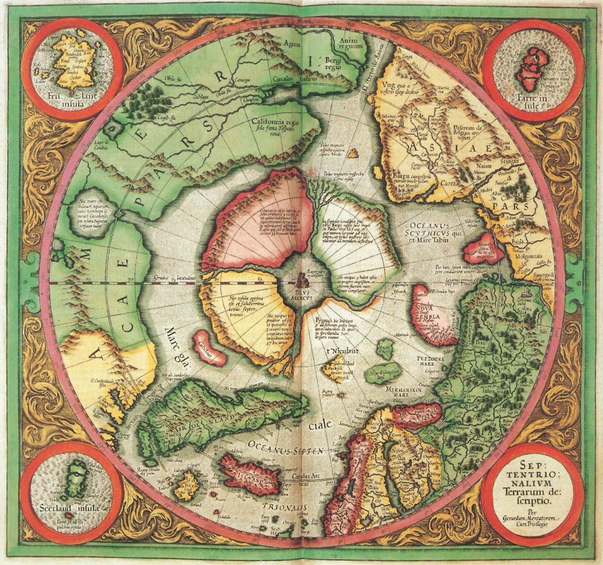
The source for much of Mercator’s representation of the north Atlantic was a book published in Venice in 1558, described as an account of the fourteenth-century voyages of the brothers Antonio and Nicolò Zeno, and accompanied by a woodcut map. The book was compiled from family papers by Antonio Zeno’s great-great-great grandson, also called Nicolò, a respected writer, mathematician, and geographer, and member of the city-state’s Council of Ten. Around 1380, so the story goes, Nicolò Zeno left Venice on a trip to England and Flanders, but was blown wildly off course by a storm, and shipwrecked on an island which, he subsequently discovered, was called Frisland. Attacked by the natives, he was rescued by Zichmni, prince of nearby Porlanda; the two formed an alliance, Zichmni becoming lord of Frisland and the neighboring islands of Ledovo, Ilofe, and Sanestol with the help of Nicolò’s naval know-how.
This information is said to come from letters Nicolò wrote to Antonio Zeno, who then joined his brother in Frisland, and continued in Zichmni’s service for ten years after Nicolò’s death. Together, Antonio and Zichmni led expeditions to Grislanda, Engroueland, and Icaria, meeting hostile natives, stunted cave-dwellers and practically-minded monks who fashioned all manner of things from volcanic rocks. Further discoveries are mentioned in material supposedly drawn from another letter, this time from Antonio Zeno to another brother, Carlo. These were not made by Antonio himself, but were narrated to him by a Frisland fisherman who, blown off course, found himself among the savages of Drogeo, where he lived for many years before escaping to Estotiland. Here the fisherman found the king’s library stocked with books in Latin—evidence of some earlier European contact—and heard tell of more civilized peoples, of cities and great wealth lying to the south, seemingly a reference to the settled tribes of North America or perhaps Mexico.
All of these places appear on the “Carta da Navegar” which accompanied the book. The tip of Scotland can be glimpsed at the bottom of the map’s centre, and Denmark, Sweden, and Norway are recognizable and duly labelled; above Norway is a gulf, with Europe’s landmass looping across the top of the map to “Engronelant”—as Greenland was often then known. Iceland, too, appears, though it has acquired seven unfamiliar extra islands to the east. Indeed, apart from the slightly misplaced Shetland islands—here “Estland”—everything else on the map, though scrupulously labeled, is entirely fictional.
Within only a few years of their publication, however, these details had all been incorporated into standard cartography—starting with the 1561 edition of Ptolemy published in Venice, which was widely reproduced thereafter and used as the basis for subsequent maps. Sailors navigated the North Atlantic assuming the existence of Frisland, Estotiland, and Drogeo—Frobisher had actually landed on Greenland when he thought he was planting the English flag on Frisland—and around a hundred years passed before enough journeys were made and reports filed to confirm that where Zeno had carefully mapped out islands, there was nothing but sea.
Had Zeno simply made it all up, and if so, why? If it had been genuine, his map would have been well in advance of European knowledge in 1380. Greenland appears more clearly defined than on any other maps before the mid-sixteenth century, and the tip of Estotiland seems to match the location of Labrador, long before John Cabot’s voyages. Indeed in 1898, the British geographer Frederick Lucas wrote a meticulous, schoolmasterish demolition of Zeno’s account, in which he observed that the antedating of the map could be seen as an indirect claim for the discovery of America by a Venetian—scoring a point or two against rival Genoa, Columbus’s city of origin. It seems likely that Zeno mingled what was known of the north Atlantic in the mid-sixteenth century with a handful of inventions and transpositions—moving the Faroe Islands next to Iceland, planting Faroese place-names on Frisland. Even Frisland was not entirely his invention—Catalan maps and Italian portolanos of the fifteenth century contain islands variously called Fisland, Fixlanda, and Frislanda, widely thought to be versions of “Fishland,” and to refer to Iceland or the Faroes, both known for their plentiful supplies of fish.
Zeno’s account itself is not wildly fanciful or fantastic—no giants or many-headed beasts, no gravity-defying cities or talking horses; there is no sense of satire or deeper political or moral purpose, as with More’s Utopia or Montaigne’s cannibals, no agenda other than the transmission of information. In fact, there are relatively few details: a fuller description of Frisland is promised by Antonio Zeno for another volume, and that of other places is laconic enough to seem sober and unembellished. Some of what appeared on the map was either correct or commonly conjectured, and this seems to have been enough for the rest simply to be accepted. And after all, Nicolò Zeno was a man of some reputation, in a city whose wealth was built on trade and intelligent navigation; he was also, crucially, the editor of the northern section of the 1561 Ptolemy, and was thus uniquely placed to insert his imaginary countries into an authoritative context, from which they drew life for years to come.
Many geographers continued, even into the last century, to place their trust in Zeno’s map and the account of his ancestors’ travels, carrying out mind-bending contortions of Faroese place-names or Icelandic topography to demonstrate Zeno’s good intentions. Some have argued that Frisland simply sank, or else its size and solidity were overstated, and it was some sort of sandbank. (Many of the same arguments are made for Frisland’s fellow north Atlantic phantom, Buss Island, reportedly discovered in 1578, and mapped in some detail by Captain Thomas Shepherd in 1671, but rapidly forgotten, and conclusively erased from maps by the end of the eighteenth century; Shepherd, meanwhile, was kicked out of the Hudson Bay Company “on account of bad behaviour.”) Like other hoaxes, the annals of Zeno acquired a coterie of true believers—though a current website devoted to the Kingdom of Frisland has its tongue firmly lodged in its cheek, what with its images of the island’s priestesses carrying ceremonial Frisbees.
Why would Zeno lie? Perhaps the question is misconceived, and the issue of his motivation misplaced. Frederick Lucas, for one, believed he was on the trail of “a contemptible literary fraud—one of the most successful and obnoxious on record.” No special reason was needed, he notes, for Thomas Chatterton and William Henry Ireland to pen their forgeries of fifteenth-century songs or Shakespeare plays—success was its own reward. At several centuries’ remove, though, the question seems to be rather why anyone would have taken either text or map at face value. Both contain many clues as to their own spuriousness, with the map merely the most literal part of the hoax—and ultimately the most successful. Some of these signs are relatively subtle—the monastery of St Thomas in Greenland labeled not with the Latin cenobium, but Zenobium—while others parade the text’s inauthenticity before the reader’s eyes. Not only is the oral narrative of Drogeo and Estotiland embedded in a letter whose content has in turn been conveyed by the compiler; not only are these letters not fully reproduced, but merely excerpted; at the book’s conclusion, the compiler confesses that none of the original documents exist, and that he has reconstructed them from memory.
The admission which should unravel the whole story—and with it the claims to existence of Frisland, Drogeo, Icaria, Estotiland, Porlanda, Neome—is curiously moving in its contrition and contradictoriness. “I grieve that the book and many other writings... have come, I know not how, unhappily to harm; because, being still a boy when they came into my hands, and not understanding what they were, I tore them in pieces and destroyed them, as boys will do.” There is something at work here that goes beyond any subconscious desire of the criminal to be caught. Perhaps Zeno’s fiction is designed to stand in belatedly for a childhood wonder on which he missed out—the boy who destroyed the maps of distant lands instead of poring over them—or perhaps to atone for some more obscure crime of the imagination.
The motto of Zeno’s publisher, Francesco Marcolini, appears on the book’s frontispiece: Veritas Filia Temporis, “truth is the daughter of time.” Perhaps we should think of falsehood not as the opposite of truth, but rather as her wayward twin brother—a little like the figure we glimpse in Zeno’s confession, the uncomprehending, destructive child growing into a trickster whose inventions led countless ships astray.
Tony Wood is an editor at New Left Review.