En Piste: An Interview with James Niehues
The art of the ski-area map
Jocko Weyland and James Niehues
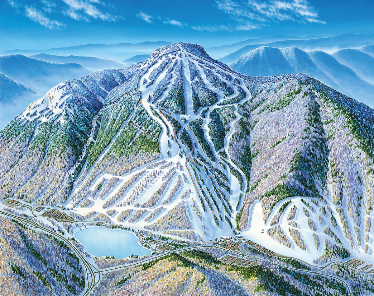
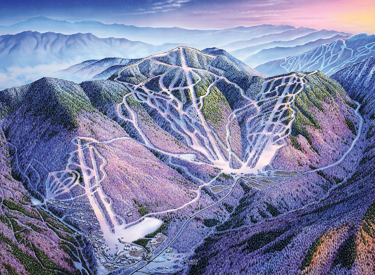
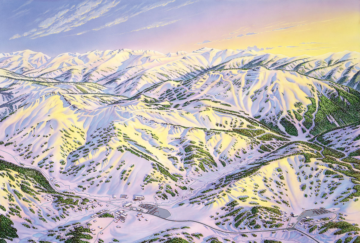
James Niehues is the unheralded doyen of the ski-area trail map, having established a near-monopoly on the genre by producing 120 of them over the last 20 years for resorts in Australia, Austria, and the United States. Niehues’s masterly panoramas marry topographical verisimilitude and effective presentation of copious amounts of information in intricately painted landscapes, all translated to 4 x 9" folded maps available to everyone who buys a lift ticket. The maps provide transportable, easy-to-use, and eminently practical guides for skiers and snowboarders, who are often in unfamiliar territory. The mountain itself, lifts, lodges, boundary lines, and the runs and their difficulty factor are all delineated with utmost precision. Almost certainly unaware of Niehues’s role, ski-area visitors use a trail map to navigate the varied terrain of snow, trees, valleys and peaks not easily comprehensible from their location on the ground. Like a road or subway map for an unfamiliar city, these handy images help visitors cognitively place themselves and move around in often disorienting spatial dimensions. Making that possible (and doing it with a minimum of recognition) is James Niehues’s job and métier.
Jocko Weyland: You grew up in Western Colorado?
James Niehues: I graduated from the Fruita High School and my parents had a farm in Loma, where they still live. When I was in ninth grade I had a kidney disorder called nephritis and I was bedridden for three months. I was always sketching prior to that time and my mother thought I was very good so she decided to get me an oil-painting kit so I could pass the time.
Were there certain artists you were interested in?
Oh no, not at that time. I just liked the scenery and I just painted.
You went into the Army?
In 1965 or so, I was stationed in Berlin with the Army Security Agency. I went down to Switzerland on leave and skied for the first time. When I came back to Colorado, Powderhorn resort was the first place I skied. I was employed by a printing company, then with a major after-market auto-instrument firm before becoming a partner in an advertising company in Grand Junction. After seven years I dissolved the partnership and moved to Denver. I had a job there working for Litigraphics, a small company that made models and displays for trials. One case involved a young lady who was paralyzed from the neck down in a crash and my job was to portray the movements of her body during the collision. She had been sleeping in the reclined passenger seat when the car struck another vehicle. I was responsible for finding the model of car and getting accurate measurements for the views. I had her weight and height, so then I made a series of drawings showing the movement from the reclining position to her striking her head and breaking her neck. It was extremely interesting work, puzzle solving, something like the maps, which I started doing in 1986.
This was around the time you met Bill Brown?
Yes, he had been doing ski-area maps ever since Hal Sheldon retired. Hal goes back; in fact Hal initiated the trail maps. He was the first one to sell the resorts on the idea of “Hey, you ought to have a nice picture of this place.” At that time I was working in various print shops and I decided to seek out Bill Brown. He had been painting maps for some time and was sort of burned out, and his new interest was making narrow-gauge railroad films, which he marketed through magazine ads. He happened to have a job to do for Winter Park’s Mary Jane side that he turned over to me. When they accepted it, he informed them that I had actually painted it and later I signed it. Then I took slides of it and took them around with a letter of recommendation from Bill to the various ski areas and started getting some projects.
Are there artists both inside and outside of your field that you particularly looked up to?
Of course Bill and Hal. I met with Hal several times and picked up various techniques that I still use today. I used to look at their maps all the time and study the colors and techniques. Then there’s Heinrich Berann out of Europe, just a fantastic illustrator. Outside of that I really enjoyed the Impressionists, Van Gogh was probably my favorite, I really liked his boldness and color.
Are aerial photographs a factor in all the maps that you’ve done?
Pretty much. You just got to see it. With bigger areas it’s pretty much required that I go on location and fly and get more familiar with the mountain than I would if I just had photographs sent to me.
Did you have any specific training in aerial photography?
Oh no, I just go out and start shooting. In fact, I’d really rather have photographs taken by an amateur than by a professional. A professional shoots for a different purpose, they try to get a good composition. I just want information. You never know for sure what direction you’re going to illustrate a certain part of the mountain from, so you just need to go around and take pictures of everything. I’ll try and shoot the mountain from every angle possible, starting at about 4,000 feet over the summit of the mountain to get some very high altitude stuff, and then I’ll drop down and get more of the detail around the lower part of the mountain.
So you get the photos back and then what happens?
Well probably before I’ve even gone up in the plane I’ve had a good idea and gone through some thumbnails with the client so we know what perspective we’re going to take. Once I get the photos back I’ll sit down and go through topographical maps and review it with the client, and then I’ll make a full-sized 30 x 40" sketch with pencil on vellum, so I can make copies if needed. The client will review it, and if there are changes I’ll make them and I’ll proceed into the final rendering, with a brush, hand-painted. I do use an airbrush in the snow parts and the sky and some of the background and then it becomes all brush.
You use gouache?
Yes, it makes it easier to make changes in the future. Once it’s approved I’ll take it down to a photo lab and have them make an 8 x10" transparency, and that will be scanned into a CD in the file size we want. Then I’ll do all the color correction I want on the computer, and then send it on to the client, and they’ll put the layers of type and all the information they want on it—the ski-lift symbols and trail names and everything else.
This is your job, but are you painting for yourself?
If you’re asking how much I’m directed by the client, it depends on the client. Some want to have a lot of control, and others say “Hey, you’re the guy, do it.” Some clients get real picky, but that’s just part of being in the commercial field. Ultimately you end up probably not painting them exactly the way you’d want to. I’d like to paint in some real storm clouds but of course marketing doesn’t want to see that. They want nice blue skies—I don’t know how the snow gets there ...
In your own art you’re painting landscapes?
I do a few but I don’t have the time. I’ll do an oil painting now and then—wet on wet with multiple layers of oil. But it’s different than the maps, where it’s like putting a puzzle together with the end result being informing the viewer as clearly as you can.
I really like the way you have to look closely to find your signature, how it’s hidden away in the trees and not immediately apparent, like Al Hirschfield’s “Ninas.” Have you always signed them?
Yes, the block letters were developed after the first couple of years and now I switched to script on the J and the N. I take great pains to put it in the right place and they’re always putting blocks of information over it or some copy [laughter].
Is there one ski-area map that you’re proudest of, or that was the hardest to do?
I’m always asked that and I resist having a favorite, for obvious reasons. One that I can point to that’s interesting, and I’ve been very pleased with it because it’s not the most dynamic mountain in the world and it’s rather spread out, is Perisher in the Snowy Mountains of Australia. It doesn’t have a lot of vertical and there aren’t a lot of defined runs on three major hills. I did it with a very low sunrise which accented the height of the hills and gave it more visual height and separation.
How do you keep distances relative and credible? Like how long is this run, how far away is that lift?
Some of it is done with color perception—your blues are farther away, and your warm colors are closer and there’s a natural perspective. You have to foreshorten areas that aren’t important and yet keep that feeling of distance in there. That’s showing the mountain as it would ski, not necessarily as a flat map. It’s difficult to explain … I just do it.
Well, obviously it works. One interesting thing is that not only have you done so many of these maps but you’re making something that so many people use without knowing where it comes from; they don’t question it. You go skiing, and there’s the map—thousands of them at the lift-ticket booth and you just grab one and put it in your pocket and go up the lift. There’s a huge amount of utility to what you do, which is highly unusual for a painter.
Yeah, there probably is. They’ll print up 100,000 of these things, and a large area will print up more than that, so it’s kind of neat that so many people do use them and rely on them.
Have you ever gotten compliments from people you don’t know?
Yeah, that’s happened. One that really stands out is the very first regional I did, for Jackson Hole, Wyoming. I did a winter and a summer view, and Jim Sullivan who runs the Snow King ski area at Jackson Hole found out my name and address, and he wrote me a really nice letter about how all of a sudden whenever he went to a tourist show he could just spread out the map, and he said, “I don’t have to explain anything anymore … now they know what Jackson is like.” He was just ecstatic.
That’s high praise.
To convey something, and clearly. That’s what it’s all about for me.
Jocko Weyland would like to thank Armin Harris.
James Niehues is a resort and panoramic illustrator, specializing in ski maps. He lives in Loveland, Colorado.
Jocko Weyland is the author of The Answer is Never—A Skateboarder’s History of the World (Grove Press, 2002) and has written for Thrasher, Pool Dust, the New York Times and other publications. He is the creator of Elk, a contributing editor to Open City magazine, and his photographs has been exhibited at the Steffany Martz Gallery in New York, the Pittsburgh Center for the Arts, and the MU Foundation in Eindhoven, The Netherlands.
Spotted an error? Email us at corrections at cabinetmagazine dot org.
If you’ve enjoyed the free articles that we offer on our site, please consider subscribing to our nonprofit magazine. You get twelve online issues and unlimited access to all our archives.