From Disc to Sphere
Taking on the whole earth
Volker M. Welter
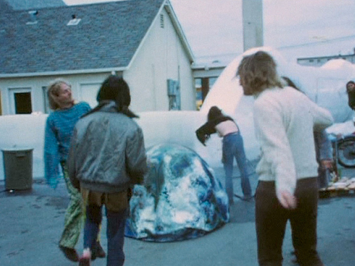
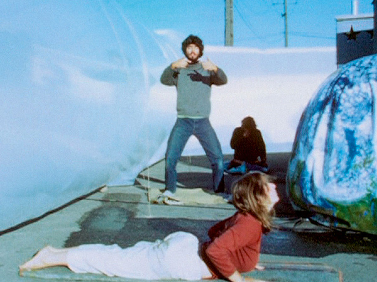
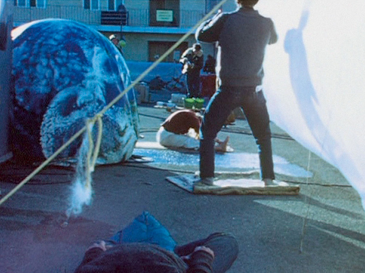
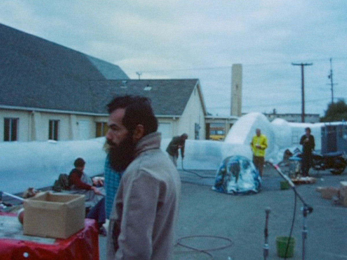
In October 1969, at the height of the irrational fears about the imminent detonation of the population bomb, about one hundred hippies assembled in the San Francisco Bay area to stage a “hunger show,” a week-long period of total fasting. The event was inspired by a hashish-induced vision that had come to the founder of the Whole Earth Catalog, Stewart Brand, when reading Paul Ehrlich’s 1968 book The Population Bomb. The goal was to personally experience the bodily pain of those who suffer from famine and to issue a warning about the mass starvations predicted for the 1970s. From the outset, the lofty intentions conflicted with a more dreary reality. Originally, the communal fasting was to be held inside an inflatable, one-hundred-by-one-hundred-foot polyethylene pillow. The structure, dubbed Liferaft Earth, was designed by Charlie Tilford, a graduate student in engineering at Columbia University, and the participants were to live exclusively within it for the duration of the fast. But the organizers could neither secure a prominent site nor a permit for the innovative shell, which was deemed to be a fire risk, and so the event took place instead in a motel parking lot in the city of Hayward. There, a four-foot-high inflatable wall delineated a compound within which those who were fasting camped. The press and the curious lingered outside the wall, joined by the occasional participant who could no longer bear the hunger pangs, made worse by the temptations of a nearby Chinese restaurant.
Symbolically, the raft also offered refuge for planet Earth. A photograph in the Whole Earth Catalog from January 1970 shows an inflated globe among the spread-out paraphernalia of the counter-cultural gathering, thus making the hunger show one of the earliest events where such a globe became part of the iconography of American environmentalism. (The globe can be seen in Robert Frank’s 1969 film of the event, Liferaft Earth; by the end, it was sadly deflated and abandoned, after inclement weather had made the group decide to relocate to the Portola Institute in Menlo Park.) Today, barely an Earth Day celebration takes place during which the participants do not pass an inflatable globe over their heads in order to express a symbolically renewed relationship with the earth. The iconology of this symbol can be traced back both to photographs of Earth taken during NASA’s various missions to outer space, and to our attempts to comprehend our environment with the help of maps and globes.
• • •
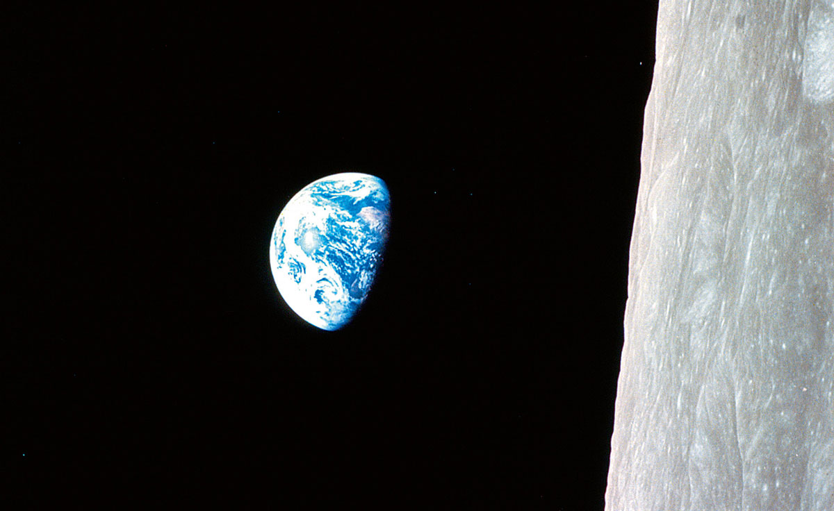
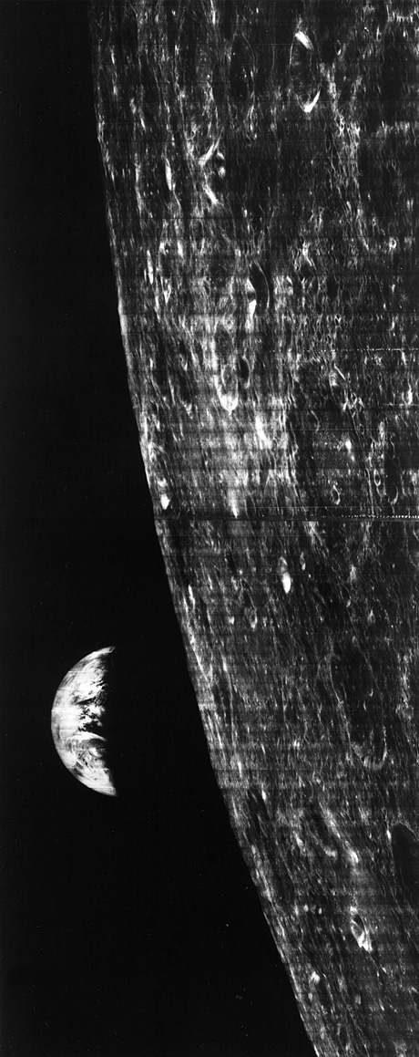
With the advent of space flight in the mid-twentieth century, man’s gaze paradoxically turned back toward the earth. The story has often been told of how the astronauts of the Apollo 8 mission in 1968 snapped, almost accidentally, photographs of their home planet when approaching it from behind the moon.[1] From that point on, images like the famous Blue Marble, shot on 2 December 1972 during the Apollo 17 flight, lent legitimacy to both the space program and twentieth-century concerns for Earth’s ecosystems.
On the one hand, pictures of Earth floating in outer space proved the viability of leaving the planet to explore the unknown. Considered from that perspective, the backwards glance was simply the last view of the home planet of an otherwise forward-looking human race—a gaze comparable, perhaps, to the fixed stare at the disappearing cliffs of England of the couple at the center of Ford Madox Brown’s 1855 painting The Last of England. On the other hand, the same images took on a near sacred aura for those who, like the advocates of the Whole Earth movement, were searching in the later 1960s for a new relationship between mankind and Mother Earth. To them, the images showed the vulnerability of a planet that appeared fragile and lonely amid the blackness of outer space.
Chronologically, however, inflatable earth balls preceded such imagery, and became the first symbol that 1960s environmentalism adopted in order to act out a new existential relationship with the earth. While playing with an inflatable globe seemingly promoted this emerging sensibility, the motif—man playing with the earth—in fact recalls earlier images from the history of modernity’s relationship to the planet.
Globes are one way of representing the earth. Initially of rather small size, large-scale spheres from the nineteenth century onwards allowed for more direct forms of encounter. For example, in 1851 the map publisher James Wyld erected in London a wooden sphere sixty feet in diameter that could be entered in order to study the world that was painted on the inside. It was followed in 1900 by the “Great Globe” conceived—though never realized—by the French anarchist-geographer Elisée Reclus and the architect Louis Bonnier for the World Exposition in Paris, and, fast-forwarding to the mid-twentieth century, by various globes proposed by Buckminster Fuller. In 1956, Fuller envisioned a “Minni Earth” in front of the United Nations in New York as a visual reminder of the immense scope of the organization’s global tasks. By the early 1960s, Fuller and his then-colleague John McHale from the British Independent Group had further reduced the globe to a “Miniature Earth,” a geodesic sphere covered with a textile skin upon which the silhouettes of the continents were printed. They also developed a geoscope, a small globe into which a man could insert his upper torso in order to view, through sheets of transparent plastic, flickering lights indicating world data such as the distribution of resources: “Viewing the stars through the semi-transparent land masses, from the centre of such a miniature-earth would powerfully locate man in his universe.”[2] The diminutive size of the device emphasized man’s central position even more than Wyld’s globe, as it allowed only one individual at a time to be the center of the world.
Insofar as they too adopt a bird’s eye view, aerial and outer-space photographs can be considered an extension of maps. Yet all three differ in regard to their ontological implications for man’s relationship with Earth. Some postmodern critiques notwithstanding, maps did aim at understanding the spaces they depicted. Maps not only made these previously uncharted terrains available to explorers, adventurers, and armchair travelers, but, crucially, their initial creation often relied on someone physically traversing the spaces that were subsequently represented (thus the white blotches on early modern Western maps of continents that had not yet been crossed in their entirety by a note-taking explorer). Maps also invite some minor, but conceptually important, physical activity on the part of their readers, who could unlock the abstractly presented physical space by conducting what in German are called Fingerreisen: imaginary journeys that take place by moving one’s finger from one place name to the next. Earth photographs do not entice similar sensuous engagement with abstract knowledge.
Just over one hundred years passed between the first camera image of a section of the earth, photographed by Nadar from a balloon in 1858, and the extraterrestrial views of segments of our planet taken by the US satellite Explorer VI in August 1959.[3] In between, hot air balloons offered views of Paris, reconnaissance kites allowed for glimpses into enemy trenches during the Great War, and in World War II airplanes achieved the same. In the postwar period, architect Erwin A. Gutkind argued for regional planning on the basis of military aerial photographs that made visible the land between Boston and New York. These images are among the earliest examples of partial earth views buttressing environmentalist thought; Gutkind’s essay opened the published proceedings of the 1955 conference “Man’s Role in Changing the Face of the Earth” at which the ecological achievements of past and present world civilizations were discussed.
The instant visual overview that photographs of the earth offer suggests usefulness comparable to that of maps. Yet, in the words of art-historian-turned-geographer Denis Cosgrove, though “intensely geographical” such images are not, therefore, “cartographic image[s]”—while maps represent in an abstract manner, high-altitude aerial and extraterrestrial photographs offer a more direct, if unusual, depiction of reality. [4] Moreover, these two kinds of photographs themselves differ with regard to scale and the sophistication of the technical equipment used, a difference that marks a fundamental change in man’s relationship with planet Earth.
Already in the 1880s, the British painter Philip Gilbert Hamerton distinguished landscape paintings from bird’s eye views by pointing to a qualitative shift from the world as “men see it who dwell in it, and cultivate it, and love it” to the “world as the angels may see it from the midst of space.”[5] The increasing ability of later twentieth-century man to view the earth from ever further away in outer space constitutes another qualitative shift, this time from viewing parts of the planet to seeing the whole. Looking at a segment of the globe from above mimics the traditional angle of vision of the human eye; almost irrespective of the height, the view remains connected to the viewing subject which, in turn, stays tied to the earth as the object of the glance. Gazing at the entire globe from outer space no longer means looking down, but back from a distance. The height of the former viewpoint is measurable with regards to a base, usually the surface of the planet; the act of measuring establishes, together with gravity, a clear sense of above and below. The loss of this grounded dimension in gravity-free outer space means that height morphs into mere distance between objects, such as spaceships full of astronauts and planets like the earth. Consequently, outer-space travel initiated, according to philosopher Günther Anders, a process of “spatial distancing from the earth” that gradually revealed our planet as “an ownerless celestial body, the flotsam of the universe,” while accompanying outer-space photographs illustrated man’s “cosmic eccentricity” as an accidental bystander somewhere in space.[6]
Until outer-space photography truly took off in 1946, when a US program affixed cameras to captured German V2 rockets, extraterrestrial depictions of the earth relied on human imagination and interpolations from existing knowledge. In 1885 Hamerton envisioned the final leg of Archangel Raphael’s journey from Heaven to Earth with the words, “At last, when we come within … twenty thousand miles, we should distinguish the white icy poles, the vast blue oceans, the continents and larger islands glistening like gold in the sunshine, and the silver-bright wandering fields of cloud.”[7] Not surprisingly, British astrophysicist Fred Hoyle arrived at a similar impression when he anticipated, during a 1949 BBC radio lecture, the coming of a whole earth picture: “There will be all shades of green, varying from the light green of young crops to the sombre darkness of the great northern forests. The desert will show as dusky red, and the oceans will appear as huge areas that look grimly black.”[8]
At the time of Hoyle’s lecture, the American V2 program had already delivered the first outer space images from sixty-five miles up. Technology progressed rapidly. In 1959, rockets reached seven hundred miles and Explorer VI offered an early, more permanent base in outer space for taking photographs. Other satellites followed in quick succession until, in August 1966, Lunar Orbiter I sent an image showing the earth partially covered with a semicircular shadow thrown by the moon.[9] Contrary to Hoyle’s claim that “the whole spectacle of the Earth would very likely appear … as more magnificent than any of the other planets,”[10] the earliest photographs were not all that impressive. They showed semicircular or near-circular shapes set against streaky black and white backgrounds.[11]
Nevertheless, newspapers welcomed every new image as a “first” with regard to distance from Earth, technical equipment used, and size of surface captured. The V2 pictures from 1946 were followed a year later by the first picture from the landmark a altitude of one hundred miles. The “First Television Picture of the Earth from Space” was broadcast in 1959; 1966 saw both the “First Picture [that] shows Cover of Clouds,” and the first picture of the full earth, courtesy of the ATS 1 satellite, one free of any shadow cast by the moon and therefore resembling a circle or disc (as opposed to the sphere of the whole earth).[12] Thereafter, things turned colorful with the US Navy’s DODGE satellite supplying a color picture on 25 July 1967, and NASA’s first following on November 16.[13] This series of “firsts” recalls Anders’s interpretation of the way in which every forthcoming space flight during the 1960s was anticipated as “historic.” The inflationary use of the adjective did not retrospectively identify truly influential past events. Instead, it reduced the “historic” to a present that was instantaneously superseded by the next occurrence.[14] Comparably, to call every new Earth image “first” transformed awesome technological achievements into fleeting moments; almost as soon as they were shot, extraordinary images became ordinary by being drawn into the realm of the everyday.
Moreover, until photographs of the entire earth were technically achievable, the limited field of view available from lower altitudes meant that the frame of the photograph dissected the planet into random pieces. Even if Earth’s curvature was visible in an individual image, little conveyed that these sections were parts of a larger celestial body with defined geometrical limits or even with limitations concerning, for example, its ability to support human life. To arrive at the second viewpoint required a neo-Malthusian gaze that recognized the geometrical circumferences as expressions of the planet’s limited resources; this became the popular view of the Whole Earth ideology from the later 1960s onwards.
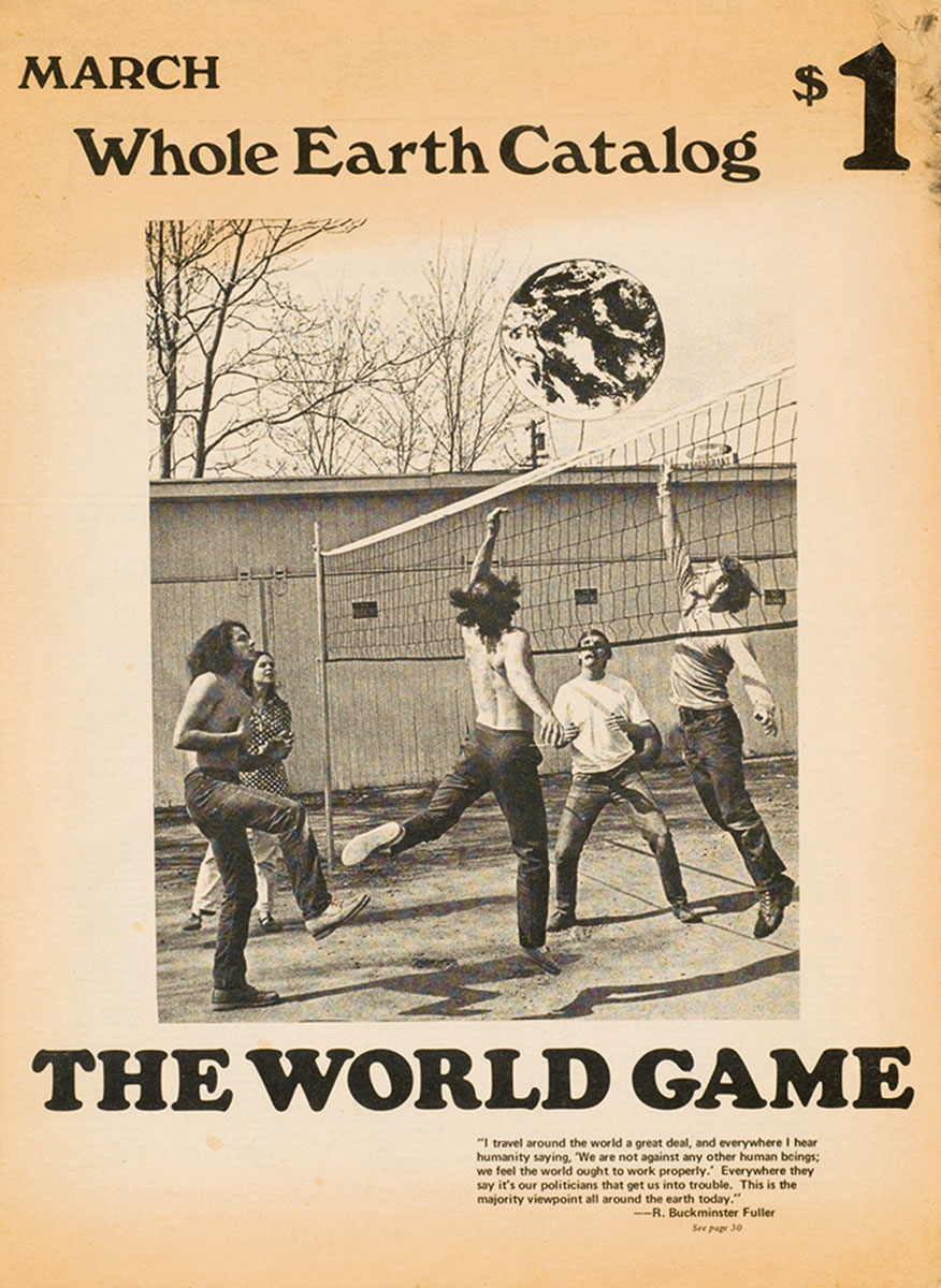
As Stewart Brand began to ponder in early 1966 the ideas that eventually crystallized in the Whole Earth Catalog, he started selling little white buttons that asked: “Why haven’t we seen a photograph of the Whole Earth yet?” Crucial is the adjective whole, as Brand explained in a later essay, for “the earth [is] curved … closed on itself.”[15] This fact, while knowable in the abstract, had not up until then been visible to the inhabitants of the planet; thus, he continued, “people perceived the earth as flat and infinite, and that ... was the root of all their misbehavior.” Changing such erroneous perception required the holistic expansion of man’s consciousness, to fully grasp “that it [Earth] was curved, think it, and finally feel it.” Subsequently, Brand conceived “a six-foot diameter canvas and rubber pushball of the type he had played with in Army boot-camp training. This one [was] painted with continents, oceans, and cloud swirls.”[16] This first “earth ball” was created in 1966 for the New Games, an initiative that aimed at channeling human aggression into non-competitive and peaceful tournaments. In short, two years before an image of the entire earth was featured in 1968 on the cover of the Whole Earth Catalog’s inaugural issue, Whole Earth environmentalism had already adopted as its symbol an inflatable globe that mimicked the earth as seen from outer space rather than being a three-dimensional model of a two-dimensional world map.
Inflatable earth balls also addressed a major visual drawback of the 1966, first-ever photograph of the full earth, namely, its flat, disc-like appearance—a rather unfortunate result given that man’s long quest for outer space travel had begun with the realization that the earth was not the flat center of the universe. While photographs of flat discs did not nourish a sensuous encounter between man and Earth, cuddly inflatable earth balls almost instinctively did. Games with the rubber sphere started by collectively “donating one’s breath” to the earth.[17] Having thus taken possession of the planet by inflating it, earth balls were thrown around, rolled up and down hills, and had to endure hirsute hippies throwing themselves at and over them as everyone welcomed “the chance to play with the planet, whether … pushing, passing or throwing it; kicking or hugging it; on top, beneath, or against it.”[18] This may have been a joyful and novel interaction, but the ease with which the earth was turned into a toy firmly roots this motif in modernity.

In antiquity, Atlas could barely move, so heavy weighed the planet on his shoulders and so tight was the link between man and Earth. Modernity gradually took that weight off man until space travel tore apart his final ties to Earth by offering what Anders called an “opportunity for abstraction,” the latter word derived from the Latin word for “to tear away from.”[19] Along the path toward the ultimate extraterrestrial step, man had often dreamed of playing, for good or ill, with his planet. In Grandville’s Juggler of Universes (1844), a clown casually tosses planets, an early warning not to interfere with either the natural course of the universe or the earthly order of things; Charlie Chaplin’s Great Dictator (1940), in which the despot twirls the globe on his finger tip, warned about a different, deadly presumptuousness, in this case that of 1930s Germanic man. Despite all these warnings and apprehensions, during the 1960s and 1970s earth balls were nonchalantly kicked across New Games fields and hit over volleyball nets.
Considering that extraterrestrial travel had catapulted man into spatial dimensions so vast as to be unfathomable, this reaction may astonish. Yet, one response to the expansion of human experience, argues Anders, was to reign in the newly accessible universe by drawing it back into an orbit that was solely defined by the scale of the human mind and body. Accordingly, for some, accepting this new dimension of human life meant merely determining the best place for the box through which the universe would enter their homes in the form of TV signals: “To the right the record rack, to the left the house bar, and in the centre, the universe hovers as a third piece of furnishing.”[20] This focus on human spatiality is why it was not the Lunar Orbiter I photograph of the whole earth published in 1966[21] but instead a near-identical one, taken two years later from Apollo 8, that acquired fame as the iconic “earthrise” image. This was, first of all, because it was astronauts, and not a satellite, who took the photograph; more importantly, however, the earthrise image was at some point flipped ninety degrees, a move that shifted the moon from its upright position at the right edge of the frame to a horizontal one that grounded man again in relation to a recognizable horizon.[22]
Others, for example members of the counter-culture, tried to grasp this new universe through a parallel expansion of human consciousness. By tossing around the earth in the form of an inflatable ball, they symbolically adopted outer space as their newest playground. And yet, as their own literature makes clear, they never managed either to escape Earth’s field of gravity or to counter mainstream culture. Instead they simply rehearsed well-established modernist tropes: playing with the globe, as a New Games movement leader, Andrew Fluegelman, asserts, should be understood as nothing more than “a basic human drive for ascension, or simply the wish to be ‘sitting on top of the world.’”[23]
The research for this article was supported by the Canadian Centre for Architecture, Montreal, where I was privileged to be a scholar in residence during the summer of 2009.
- For example: Denis Cosgrove, “Contested Global Visions: One World, Whole Earth, and the Apollo Space Photographs,” Annals of the Association of American Geographers, vol. 84, no. 2 (June 1994), pp. 270–294; and Robert Poole, Earthrise: How Man First Saw the Earth (New Haven: Yale University Press, 2008).
- John McHale, “The Geoscope,” offprint of article, no source given, no date, no page. Available in the archives of the Canadian Centre for Architecture, Montreal (BIB 194082).
- See grin.hq.nasa.gov/abstracts/gpn-2002-000200.html [link defunct—Eds.]. Accessed 14 September 2010.
- Denis Cosgrove, op. cit., p. 275.
- Philip Gilbert Hamerton, Landscape (London: Seeley & Co., 1885), pp. 3–4.
- Günther Anders, Der Blick vom Mond: Reflexionen über Weltraumflüge (Munich: C. H. Beck, 1970), pp. 66, 59, 60. All translations by the author.
- Philip Gilbert Hamerton, op. cit., p. 3.
- Fred Hoyle, The Nature of the Universe: A Series of Broadcast Lectures (Oxford: Basil Blackwell, 1950), pp. 9–10.
- New York Times, 26 August 1966. See also grin.hq.nasa.gov/abstracts/GPN-2000-001588.html [link defunct—Eds.]. Accessed 14 September 2010.
- Fred Hoyle, op. cit., p. 10.
- See for example grin.hq.nasa.gov/abstracts/gpn-2002-000200.html [link defunct—Eds.]; for an image taken from Explorer VI on 14 August 1959. Accessed 15 September 2010.
- The Chicago Daily Tribune, 21 November 1946; The New York Times, 21 March 1947; The New York Times, 29 September 1959; The New York Times, 26 August 1966.
- Beaumont Newhall, Airborne Camera: The World from the Air and Outer Space (New York: Hastings House, 1969), pp. 118–121.
- Günther Anders, op. cit., pp. 68–70.
- Stewart Brand, “Why Haven’t We Seen the Whole Earth?” in Lynda Rosen Obst, The Sixties: The Decade Remembered Now, by the People Who Lived It Then (New York: Random House, 1977), p. 168. Italics in the original.
- Andrew Fluegelman, ed., The New Games Book: Play Hard, Play Fair, Nobody Hurt (Garden City, NY: Headlands Press, 1976), p. 9.
- Ibid.
- Ibid., p. 143.
- Günther Anders, op. cit., p. 66.
- Ibid.
- The New York Times, 26 August 1966.
- Compare the version of NASA image 68-HC-870 grin.hq.nasa.gov/images/small/gpn-2001-000009.jpg [link defunct—Eds.]; with the one at images.jsc.nasa.gov/lores/AS08-14-2383.jpg [link defunct—Eds.]. Both accessed 14 September 2010.
- Andrew Fluegelman, op. cit., p. 67.
Volker M. Welter teaches architectural history at the University of California at Santa Barbara. He is the author of Biopolis: Patrick Geddes and the City of Life (MIT Press, 2002). His book Ernst L. Freud and the Case of the Modern Bourgeois Home, a study of the work of the architect-son of Sigmund Freud, will be published by Berghahn Books in 2011.
Spotted an error? Email us at corrections at cabinetmagazine dot org.
If you’ve enjoyed the free articles that we offer on our site, please consider subscribing to our nonprofit magazine, which includes unlimited access to all our archives.