The Jerusalem Labyrinth
Lose yourself
George Prochnik
A double puzzle: Why has Jerusalem been likened to a labyrinth for centuries? And how do we exit this maze?
Slip up onto the rooftops of the Jewish Quarter at night. A series of narrow, semi-hidden stairways allows one to ascend to an elevated sea of rippling stone, which extends north above a cluster of residential dwellings to canopy part of the shuq inside the Muslim Quarter. It’s an enchanted vantage point, almost always quiet, trellised with light breezes. The horizontal view over the Old City is expansive. The sky above is huge and star-pinned. One can feel transported through time; famous rooftop scenes from Scripture glimmer just beyond the railings. But it’s more likely that one’s company on this platform will be a pair of young haredi men in long black gabardines, seated close together, speaking in low voices, fingers twirling in their side curls; or a soldier with knitted kippah, gun strapped to his back like a futuristic pogo stick.
Step to where there’s a good view northeast. From here, it’s possible to see why the sight of Jerusalem provoked Mark Twain to declare the city just about “ the knobbiest town in the world.” Today, antennas and satellite dishes make the little domes appear pricked with an array of elaborate hors d’oeuvre forks. Twain noted also that when one gazed down from a height upon Jerusalem’s mass of houses, they are “so closely crowded together … that there is no appearance of streets at all.” This vision was nothing new in Twain’s time. Scholars of the city have long noticed that biblical descriptions of Jerusalem contain almost no mention of streets in the sense of “broad places,” except when poetic license was clearly at work. “The locusts, besiegers and death are pictured by the Prophets as entering the windows and houses directly from the walls,” observed George Adam Smith, an early twentieth-century theologian.
Density of habitation, such that from certain perspectives streets cease to exist, seems an obvious first clue to why Jerusalem became identified with the labyrinth. But it’s a false turn. By the nineteenth century, vacant lots pocked the city’s quarters. Fallen stones were everywhere. A visitor to the ruins of the massive Church of the Knights of St. John in the Muristan in 1865 described passing beneath a Norman arch “rich with … marble columns and carved capital,” only to climb over “a dust heap, where vegetables and dead bodies of dogs and cats were rotting, where flies and fleas were regaling themselves, and half-naked, wretched-looking children were playing and munching melon parings.” Before the end of the century, the church’s last walls had collapsed. The best stones were hauled off to other building projects; those left behind were soon buried in layers of debris. An axial district of the city had been reduced, as one traveler reported, to “heaps of rubbish, patches of flowering field-beans, straggling arms of the prickly pear, rising forbiddingly aloft, and here and there a fig tree.”
If not density, perhaps randomness—the impression of anarchy prevailing in Jerusalem’s alleyways—holds the key. “As might be expected the streets go winding about in every conceivable direction, making the plan of the city an admirable labyrinth,” scoffed one pilgrim, striking a familiar note in the 1869 Ladies’ Repository.
Jerusalem’s side streets have always struck travelers as tacked-on afterthoughts. Until well into the twentieth century, they were often not named at all—or, more confusingly, were given multiple, unrelated names. The latter problem has resurfaced recently as the municipality replaces various Arab street names with Hebrew ones where Jewish sovereignty and historical sites are being foregrounded. In the mid-nineteenth century, Titus Tobler, “father of German exploration in Palestine,” had to dedicate a full chapter of his opus on Jerusalem just to determining how many streets the city contained. He settled on 170, although, he added, the number was in flux. The English historian and traveler William Hempworth Dixon declared streets, in a European sense, to be literally absent from Jerusalem. “An Arab who has a thousand words to express a camel, a sword, a mare, has scarcely one word which suggests a street. A Hebrew has the same poverty of speech; for such a thoroughfare as the Broadway, the Corso, or the Strand, is quite unknown to the East. … It must have quarters; but it need not have the series of open ways, cutting and crossing each other, which we call streets.”
Yet the notion that streets are for getting between places proves insufficiently elastic for the plan of the Old City, which suggests that streets might not only function as passages along which to arrange shops, or seams in which to concentrate a people or a faith, but also as ploys to intentionally misdirect strangers. As Dixon noted of Jerusalem’s quarters in the 1860s, sometimes “free communication is not desired.”
The older city perched on two rocky spars, gradually spilling down those outcrops to pool and swirl around the district’s jagged hills, spreading wherever there was room, eventually to the edge of the ravines that carve crooked veins around Jerusalem’s high places. Sometimes residents burrowed still further down, into caves that pock the sides of these declivities. Before King David’s arrival, the Jebusites, a Canaanite tribe, lifted a citadel of stone on one of the two main promontories using the stones that Jerusalem has been roused up from, and shattered back into, countless times. The Israelites conquered the Jebusite fortress and began building on that site, which came to be known as the City of David—the center of his people’s religion, and later the site of the two temples that formed the axis of Jerusalem’s physical and spiritual identity until the final Roman conquest twelve hundred years later. The city’s abiding claim to divine exceptionalism for Jews, Christians, and Muslims alike began in that small, unprepossessing town with more roofs and ramparts than space to breathe.
The grid of streets inscribed into the ruins of Jerusalem after Titus razed the city in 70
Jerusalem’s Roman axis was preserved through all the subsequent layers of street building activity in the Old City—and helped define the boundaries of its quarters up until today. Between the remains of the original Roman network and the street pattern that emerged alongside the surge of monument building that occurred during the years of Crusader rule between 1099 and 1187, Jerusalem’s core grid took on its abiding form. But despite the appeal of this easily navigable street plan for commerce and government control, at later stages in the city’s development this grid was intentionally disfigured, scrawled over and interrupted. A curious situation developed wherein fragments of clear street geometry abutted dark muddles of alleyway. What prevented the city’s builders in centuries closer to our own from just magnifying the template of geometric clarity they had inherited?
To most nineteenth-century European and American visitors, Jerusalem’s labyrinthine elements figured as architectural stigmata signaling the city’s larger decline. The fall of Jerusalem was a leitmotif in the journals and letters of disappointed pilgrims, and a perennial favorite theme for artists. When the Victorian painter Henry Courtney Selous exhibited his two enormous paintings Jerusalem in Her Grandeur and Jerusalem in Her Fall in England in the 1870s, they attracted five hundred thousand visitors before being shipped on to a stunningly successful tour in the United States. The voluminous press coverage garnered by the show focused overwhelmingly on the second painting since—as writer after writer averred—“Jerusalem in Her Fall” depicted Jerusalem as any traveler could actually verify the city to be today.The New York World noted that in “Jerusalem in Her Fall” the artist’s “intense truthfulness and fidelity” was “to nature herself.” By rendering so vividly an image of Jerusalem his contemporaries could discover for themselves, Selous conferred retroactive legitimacy on his vision of the glories Jerusalem must once have possessed.
From this Western Christian viewpoint, the maze of Jerusalem was symptomatic of spirituality as such having lost itself in the downward spiral of the city’s Ottoman incarnation. Labyrinthine streets thus epitomized the entropic deliquescence of the Oriental. The author of one typical travel piece in a weekly publication from the 1820s recounted how in Jerusalem “you tread upon loose stones, and are enveloped in clouds of dust:—pieces of linen spread from the top of one house to another increase the darkness of this labyrinth:—which is rendered still more dismal and disgusting by covered markets exhaling a most pestilential odor.” Disorientation and odiferous engulfment mark the full inversion of Jerusalem’s divinely conceived identity, howsoever sketchily realized at any stage in history. I once was found, but now I’m lost.
The notion that loss and lostness define Jerusalem’s latter-day identity is, indeed, one point of consensus between the city’s faiths and peoples: for Jews from the time of the Roman conquest until 1967, loss of access to the most historically dense physical site of their faith (the Wall and its precincts); for Christians, loss, or at least deferment, of the promise of the heavenly Jerusalem’s descent and superimposition over the physical city at any historical stage; for some contemporary Palestinians, it’s precisely the Ottoman period that is cited as, if not the realization of a sacral prophecy, still a kind of golden age when the people found themselves at home in Jerusalem.
There was, in fact, more method to the murkiness of the street plan when the city was under Ottoman rule than its Christian visitors recognized. The snarl of off-the-grid alleyways—which increased dramatically in the reconstruction of Jerusalem that followed a devastating earthquake in 1834 and became yet denser in successive waves of development throughout the nineteenth century—was designed less to extend points of interconnection than to protect segregated communal sanctuaries from external threats. One might think of a dense network of streets being fitted over the Roman grid, then purposefully given a hard, counterclockwise twist. Many streets that seem to arbitrarily run nowhere in fact are thus calculated stratagems for misdirecting brigands and other intruders. The tactic functions in relation to threats from natural elements as well. Pilgrims’ complaints about fabric overhanging the streets that increased the maze’s darkness and stench fail to acknowledge the essential shade provided by the covering.
Applied to Jerusalem, this conceit of the maze harkens back to ancient connotations unrelated to the figure’s later popularity as a game. Though the question of whether the maze beneath the palace of King Minos on Knossos really existed has not been definitively answered, we know that the elliptical and square mazes engraved on numerous Minoan coins in the fourth century
The slow emergence of connecting streets between residential neighborhoods in post-Roman Jerusalem evokes the growth of a spider conch’s carapace, which develops in a winding spiral with bumps around its outer surface that, when the conch is young, are long and spiky to guard against predators, but become less prickly as the conch gets older. However, there’s another way of reading this model of urban growth, which would evoke other ideas of the labyrinth.
But what does the model of the city as a construct of wonder have to do with its image as a maze?
Etched into the paving stones of numerous medieval churches in France and Italy are elaborately choreographed whorls that sometimes have the word for “heaven” at their center and sometimes the word for “Jerusalem.” A slab of stone set into the floor at St. Omer was carved with a particularly enigmatic version of this conceit. Mountains, rivers, towns, roads, and animals orbit around a large circle, together with the word Jérusalem, while the interior of the circle is divided into three horizontal compartments studded with various objects that have become indistinguishable through wear. Most of the designs share a more obvious formal resemblance to classic pre-Christian labyrinths. But all these medieval church patterns came over time to be grouped under the rubric Chemin de Jérusalem—Way of Jerusalem. How they acquired this generic name and what they are doing at such a conspicuous position in Christian sacral spaces is now contested.
But the question of their provenance seems only to have become acute in the nineteenth century, when these geometric ornaments were linked to an array of long-established allegorical correspondences between the maze and the soul’s condition in the absence of salvation. (The labyrinth exemplified the state of spiritual lostness, distraction, temptation—and sometimes, also, a path inviting the righteous on a journey toward escape from the predicaments of both sin and mortality.)
The first church mazes had entrances on their western sides, with courses unfolding along a west-east axis in a manner consistent with the trajectory followed by the archetypal spiritual pilgrim, who travels away from the occident (from the Latin occidere, to fall or be killed)—away from the sunset, toward which, as Hildegard of Bingen noted, the beasts of the earth direct their countenance—to the realm of dawn and, ultimately, the ideal city of Jerusalem.
Medieval texts frequently juxtapose circular maps of the world, which had Jerusalem at their center, with images of mazes. Indeed, the template of the classic church mazes was created several hundred years before such mazes were inscribed into church floors, in tenth-century monastic manuscripts, where, among other emendations, the maze became a geometrically exact circle, composed with the help of a compass. In the famous maze at Chartres, a rosette at the center represents the stars, invoking the stellar nature of god referenced in Sumerian, Babylonian, Jewish, and Roman art, and was thought to have held talismanic power. The shape of a cross, defined by gaps between different segments of the labyrinth’s courses at the four compass points, marked an important addition to the pattern’s monastic antecedents. A bronze medallion once attached to this nexus point was said to have contained an image of Theseus and the Minotaur.
Whatever theological inflection is placed on the designs, their latter-day interpreters typically looked to texts for the solution to the puzzle they present—and specifically to the way labyrinths manifested in the writings of the Church fathers. Ambrose warns of the “deceptive labyrinth of life’s journey,” from which humanity can extricate itself only by exercising will and faith in Christ. The maze figures the loss of true perspective that curses life in this world. With the enormous surge in Western Christian pilgrimage to Jerusalem that occurred in the nineteenth century, this interpretation became more closely affiliated with the physical city. The identification was reflected both in travelers’ depictions of the narrow, labyrinthine character of Jerusalem’s streets and in a new tendency to decipher the patterns on church pavements in relation to the pilgrim’s task. Most commonly, these designs were said to have been inscribed to offer penitents an opportunity to conduct a miniature, ersatz pilgrimage within their own parishes by walking the maze’s winding courses, as deepening Muslim control over the Holy Land made actual pilgrimage to Jerusalem more difficult. But this explanation, pleasing ring though it has, proves groundless since no mention of such a usage appears for hundreds of years after the mazes were carved.
Perhaps the entire notion of a straight path between the allegorical mazes described by figures like Ambrose and the physical mazes inscribed on church floors, eliminating as it does the visual lineage of the latter forms, is deceptive. For the sublime geometric order these patterns articulate is a charm against the demons of disorientation and randomness that traditionally facilitate the course of evil. The circle is an example of God’s perfection; the compass an instrument of His final unity. The spiral embodies cosmic harmony. One scholar describes its shape as a “formalized nostalgia which links our geometry with the galaxies, the solar system, the pattern of our major internal organs, the figure of the univalve shell.”
The vision of the heavens predominating in the West throughout the Middle Ages was first articulated in the fourth century
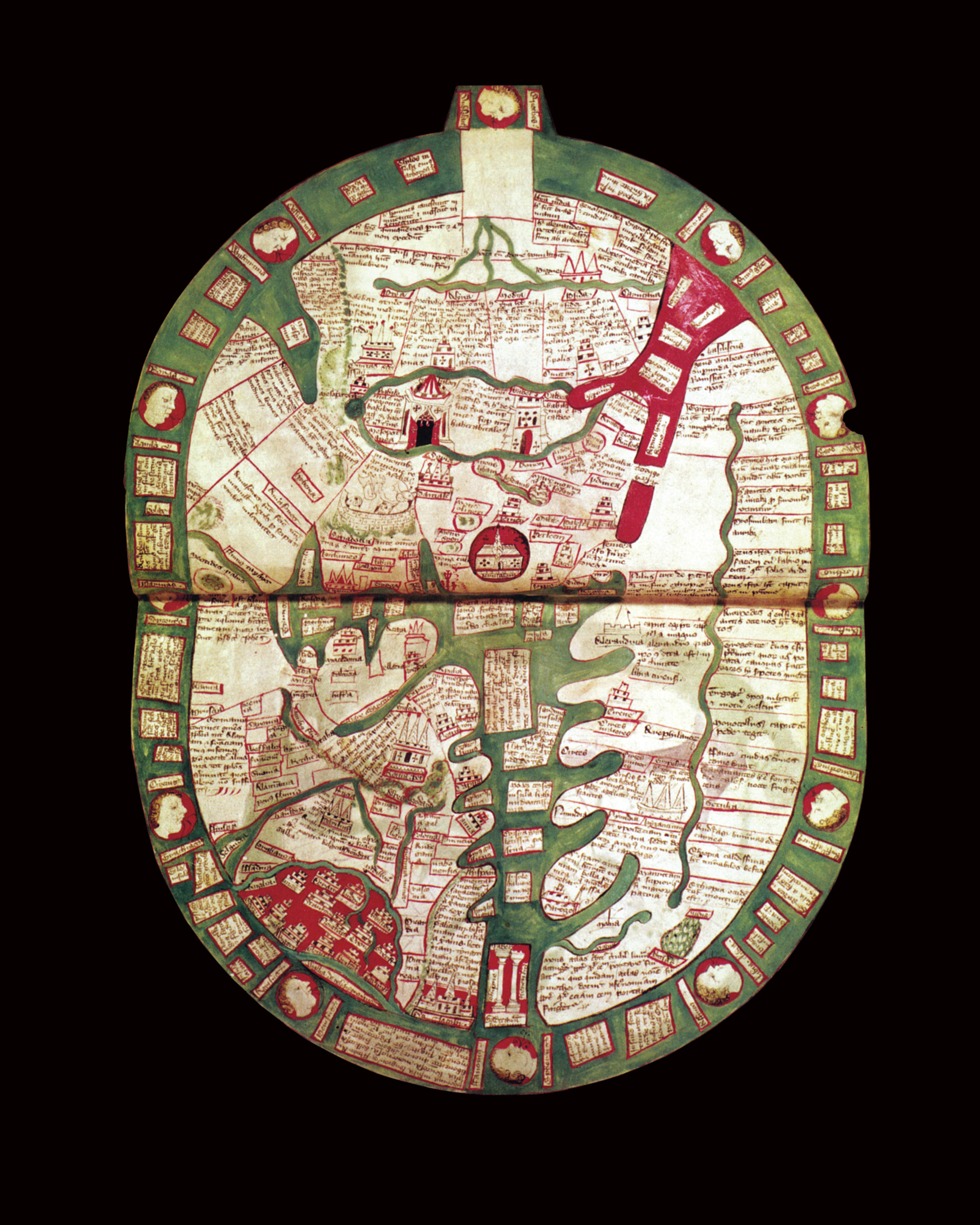
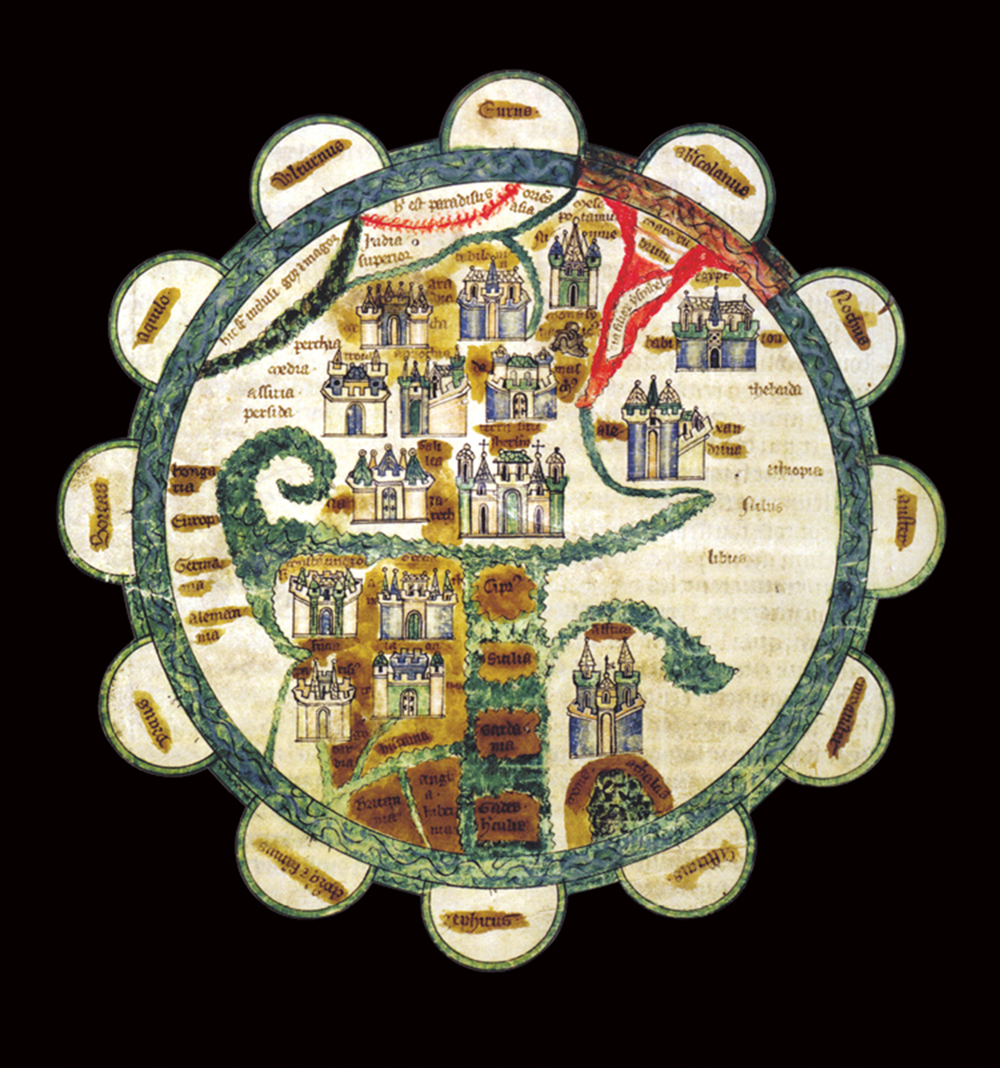
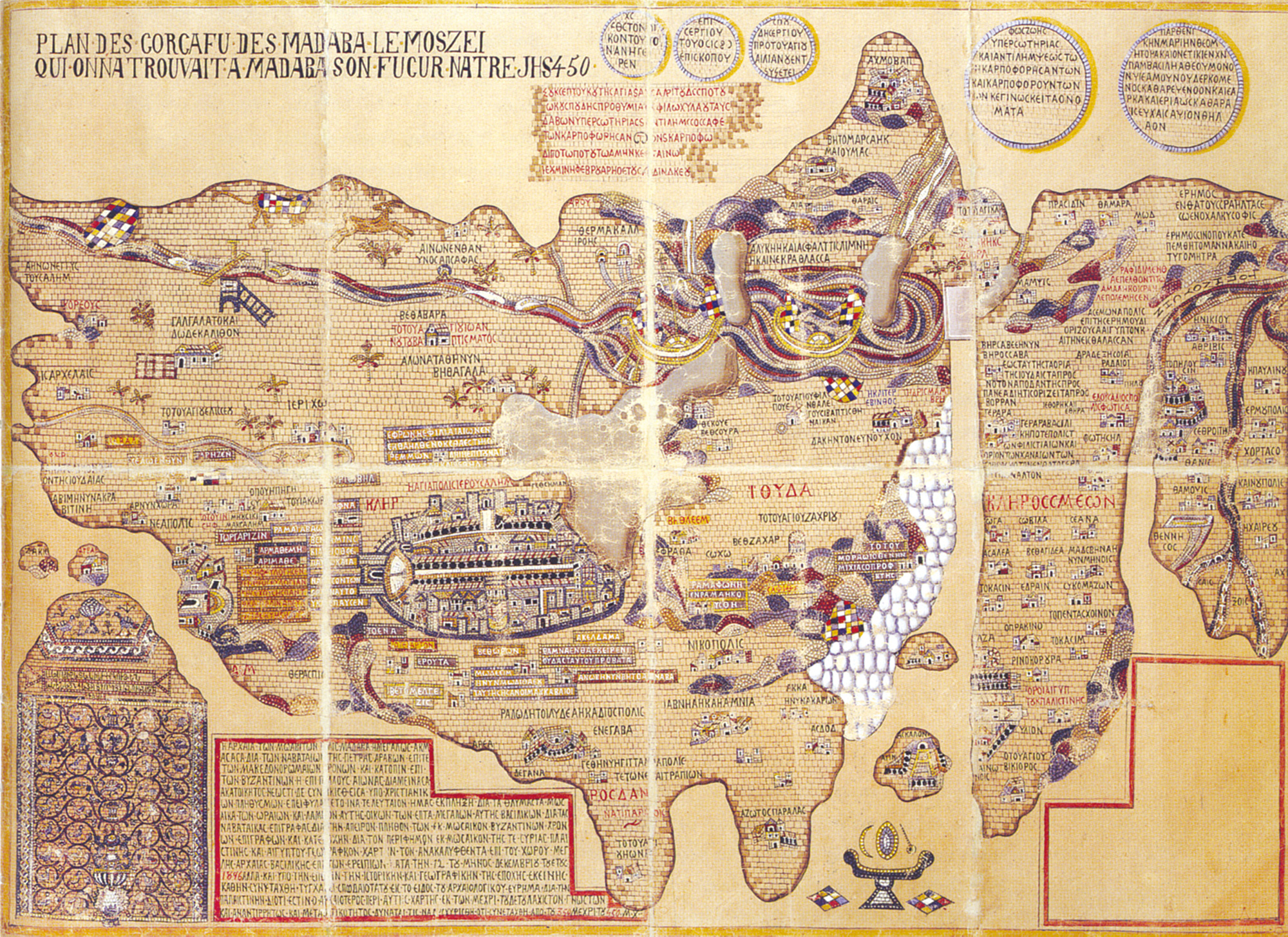
The earliest extant maps of Jerusalem, such as the Madaba map, a sixth-century mosaic found in a ruined church in present-day Jordan, represent the city as a bristly cluster bomb of its most important buildings. In the Middle Ages—when the apocalyptic dimension of Christianity, and the heavenly Jerusalem associated with this schema, received new emphasis—the cartographic model began to change. Since Christ disavowed the older, Jewish, historical Jerusalem, latter-day Christians were encouraged to orient themselves solely toward the celestial Jerusalem. Consequently, depictions of Jerusalem as such became depictions of the heavenly city. Yet, since Christians had accepted the Ptolemaic view of the cosmos, what representations of Jerusalem lost in on-the-ground accuracy they compensated for in their echoing of the actual, physical structure of the heavens as then understood. Just as the universe was pictured as an array of spheres that spun on fixed, concentric orbits around an immobile earth framed by the shell of an outer sphere studded with stars, the heavenly Jerusalem was typically depicted as a series of fixed, nesting circles—sometimes with the lamb of Christ taking the place of earth in the Ptolemaic cosmos, often with parallel sets of inscriptions charting the four cardinal directions. As the historian Bianca Kühnel has noted, in at least one instance (the illustration of heavenly Jerusalem in the Apocalypse of Valenciennes) this correlation was intended as a translation rather than a strict mirroring of other cosmological graphics then in circulation.
In some cases, maps of the cosmos and maps of Jerusalem became almost indistinguishable. In a famous illuminated manuscript of the apocalypse from the ninth century, for example, the celestial city is shown as a circular entity of concentric rings with a lamb at its center—the only interrupting element being four sets of three gates at each compass end of the circle, as described in Revelation.
With the resurgence in traffic to the physical Jerusalem initiated by the Crusades, the purely heavenly city began to crossbreed with the historical one, especially where the historical Jerusalem represented or somehow registered the religious events anticipating its future heavenly iteration. Twelve of the fourteen extant Crusader maps of Jerusalem portray the city with its iconic Christian structures in their approximately correct locations—the whole urban ensemble surrounded by a circular wall represented by several concentric circles reminiscent of ancient astronomical charts and signifying the nesting spheres of the cosmos. The cross inscribed into these maps not only further Christianizes the image but also evokes the Roman street grid.
Here’s the thing: if one ignores the words and looks just at the combination of circles within circles and pathways that sometimes connect with other pathways and sometimes lead to dead-ends, the Crusader representation of the merged historical and heavenly Jerusalem is strikingly evocative of the labyrinths being inscribed into cathedral pavements in the same era that saw the creation of the maps. Might the earliest mazes in church floors in fact have been echoing these cartographical patterns—not modeling the dangers of the world, but depicting a triumphant fusion of the ideal and mundane, the fruits of ancient astronomical speculation married to divinely mandated celestial truth? We might then postulate that the map of Jerusalem became a maze when the link between theological and scientific conventions of depicting the cosmos was lost.
“The walled Old City, with its narrow streets, is what Jerusalem is all about,” declares Fodor’s guide to Israel. “It is a labyrinth of memories, a bewitching flicker-show of colors and cultures.” The phrase resonates. But what exactly are the memories composing this labyrinth? And in what sense can they be said to be “bewitching”?
Return to the Jewish Quarter. Bright white, open to the sky, the quarter today has the least affinity of any Old City neighborhood to the Jerusalem labyrinth as defined by earlier generations. The elimination of the physical labyrinth is, indeed, what consummates this quarter’s transubstantiation into the labyrinth of memories. We encounter here, if not the arrival of the New Jerusalem, the consecration of a New Jerusalem Labyrinth.
While it may seem self-evident that the Jewish Quarter would always have included the Western Wall, in fact it was separated from that site by the Maghrebiyeh Quarter (populated by Muslims from northwest Africa) until after 1967, when that neighborhood was leveled. The parameters of the pre-1967 Jewish Quarter reflected the lack of political and economic power accorded Jerusalem’s Jewish community.
Given the choice, populations inside the walls of the Old City move upward toward the heights where circulating air means cooler temperatures and distance from the germy, mass congregations surrounding most of the great religious centers. Thus, for example, while the section of the Muslim Quarter between the major shuq streets and entrances onto the Haram al-Sharif would seem an ideal location for pious believers to settle in, public institutions were erected there rather than private residences since its atmosphere was notoriously stagnant relative to the breezy high ground of the quarter’s northern section. The latter—along with the area near Damascus Gate where economic activity was focused—drew the greatest volume of Muslim settlement. Similarly, the relative affluence of Jerusalem’s Christians throughout much of the city’s history led them to build residential quarters up near the more elevated western entrances to the Old City, while those wealthy Jewish families who could escape the larger communal confinement often moved up around Mount Zion, near the edges of the Armenian Quarter.
The Jewish Quarter itself, bordering the Dung Gate—funnel-point for the bulk of drainage and waste from all other Old City neighborhoods—had lain vacant for hundreds of years before Jews began concentrating there in the eighteenth century. The Jewish community literally got the stones that the Muslims and Christian builders rejected. Terrible indigence and commercial isolation characterized the area. In 1750, the traveler Fredric Hasselquist noted that in Jerusalem Jews had “no opportunity for trafficking. … They have no other income here than what they can get from the pilgrims of their nation.” Baedeker’s 1906 handbook encapsulated the European reaction: “The dirty Jewish Quarter … contains numerous Synagogues, hucksters’ booths, and taverns, but offers no object of interest to the traveller.”
The urge to push back the crumbling structures and dense poverty that had been emblematic of Jewish powerlessness for so long was natural. And the drive to dig down and make public what lay even further underneath the structures at the city’s low point to prove that things were once otherwise—to expose the current order as a perversion of the original elevated one—has an emotional logic of its own.
In addition to clearing back the congestion in order to build again, the post-1967 Israeli government’s investment in resurrecting and expanding the Jewish Quarter was manifested through an extraordinary commitment to archeological exploration. Immediately after the Six Day War, the entire Old City was declared an antiquities site. Digging in the Jewish Quarter may have been the most extensive ever to take place in Jerusalem. Tensions between more nationalistic and liberal archeologists played out in momentous decisions about how finds were to be catalogued and exhibited. A pair of palaces from the Umayyad Muslim dynasty discovered at the southwestern edge of the Haram al-Sharif barely escaped dismantling during the dig, and though they were ultimately incorporated into the archeological park where they were found, their presentation remains a margin note to the Second Temple story commemorated there.
Archeologists found extensive confirmation of a long-standing Jewish presence in the quarter. Indeed, everywhere they dug, they unearthed the stuff of everyday life: pottery fragments; metal buckles; hooks and nails; coins (most engraved with a star and an anchor—Jewish and Greek symbols, respectively, of the era of Emperor Alexander Jannaeus, which began a hundred years before the start of the Common Era); “sword beaters,” spatulae probably used to assist with weaving on a loom or the application of medicine and cosmetics; beads; game dice carved from bone; hundreds of shell fragments. These latter finds include innumerable worked shell discs punctured with holes and decorated with multiple “ring-and-dot” motifs in patterns echoing mazes. Some archeologists have suggested that these shells were hinged to each other and used as clappers or castanets by whirling maidens.
What excited most enthusiasm, however, was the discovery of what were described as “elaborate residences decorated in great splendor with mosaics and colorful wall paintings,” some with exquisitely patterned mosaic pavements. Among the most striking pavements uncovered in the quarter is one displaying a Roman meander fret pattern that evokes—and was probably derived from—the classical labyrinth of Greek mythology. Such adornments signified the presence not just of any Jewish community, but of an affluent, securely ensconced one.
Here, other types of memory-labyrinths begin to surface.
Almost in the same breath as these discoveries were touted for verifying ancient written testimony to the effect that the area had always been Jewish, celebrants of the finds extolled their beauty as “the best of the Hellenistic-Roman tradition.” Indeed, such ruins are largely identical to those of contemporaneous Hellenistic-Roman villas scattered around the Mediterranean. To be sure, there were also mikvehs—Jewish religious forms were observed—but in conjunction with lifestyle aesthetics dictated by the surrounding late classical world.
It goes unremarked by those looking at the discoveries through the lens of religious nationalism that the physical evidence of ancient Jewish existence in the quarter was of a Jewish life at the other antipode from that promoted by those who pride themselves on an exclusionist, militant strain of orthodoxy. What the archeological sites pointed to with pride as indicators of ethnic continuity reveal, in fact, is the continuity of rampant cultural intermingling.
And perhaps we today would do well not to fight to escape the coils of the Jerusalem labyrinth but rather to follow their winding course back and forth across the city’s confounding divisions; instead of approaching the challenge posed by this intricate pattern as a pilgrim might the long path to ultimate sanctuary, perhaps we should embrace it as an opportunity to lose ourselves.
This comprehensive bibliography accompanies George Prochnik’s article “The Jerusalem Labyrinth” in issue 49. It has been placed online as a result of space constraints in the print edition.
Anonymous, “Jerusalem,” The Friend, vol. 1, no. 19 (23 February 1828).
Anonymous, “Ten Days in the Holy City,” The Ladies’ Repository, vol. 29, ed. I. W. Wiley (Cincinnati: Hitchcock and Walden, 1869).
Karl Baedeker, Palestine and Syria, with the Chief Routes through Mesopotamia and Babylonia: Handbook for Travellers (Leipzig: Karl Baedeker, 1906).
Yehoshua Ben-Arieh, Jerusalem in the 19th Century – The Old City (New York: St. Martin’s Press, 1984.)
William Hepworth Dixon, The Holy Land (London: Chapman and Hall, 1869).
Cunningham Geikie, The Holy Land and the Bible (New York: James Pott & Co., 1902).
Sigmund Freud, The Complete Letters of Sigmund Freud to Wilhelm Fliess, 1887–1904, trans. and ed. Jeffrey Moussaieff Masson (Cambridge, MA: Belknap Press of Harvard University Press, 1985).
Hillel Geva, ed., Jewish Quarter Excavations in the Old City of Jerusalem Conducted by Nahman Avigad, 1969–1982, vol. III: Area E and Other Studies, Final Report (Jerusalem: Israel Exploration Society, Institute of Archaeology, Hebrew University of Jerusalem, 2006).
Hillel Geva, ed., Jewish Quarter Excavations in the Old City of Jerusalem Conducted by Nahman Avigad, 1969–1982, vol. IV: The Burnt House of Area B and Other Studies, Final Report (Jerusalem: Israel Exploration Society, Institute of Archaeology, Hebrew University of Jerusalem, 2010).
Simon Goldhill, Jerusalem: City of Longing (Cambridge, MA: Belknap Press of Harvard University Press, 2008).
Frederick Hasselquist, Voyages and Travels in the Levant in the Years 1749, 50, 51, 52. (London: L. Davis and C. Reymers, 1766.)
Ian W. J. Hopkins, Jerusalem: A Study in Urban Geography (Grand Rapids, MI: Baker Book House Company, 1970).
Ruth Kark and Michal Oren-Nordheim, Jerusalem and its Environs: Quarters, Neighborhoods, Villages 1800–1948 (Jerusalem: The Hebrew University Magnes Press, 2001).
Philip Kuberski, The Persistence of Memory: Organism, Myth, Text (Berkeley: University of California Press, 1992).
Bianca Kühnel, “Geography and Geometry in Jerusalem,” City of the Great King: Jerusalem from David to the Present, ed. Nitza Rosovsky (Cambridge, MA: Harvard University Press, 1996).
Milka Levy-Rubin and Rehav Rubin, “The Image of the Holy City in Maps and Mapping,” City of the Great King: Jerusalem from David to the Present, ed. Nitza Rosovsky (Cambridge, MA: Harvard University Press, 1996).
William Henry Matthews, Mazes and Labyrinths: A General Account of their History and Developments (London: Longmans, Green, and Co. 1922).
D. S. Reese, “Marine Invertebrates and Other Shells from Jerusalem (Sites A, C and L),” in Itzhak Eshel and Kay Prag, eds., Excavations by K. M. Kenyon in Jerusalem 1961–1967, vol. 4: The Iron Age Cave Deposits on the South-east Hill and Isolated Burials and Cemeteries Elsewhere (Oxford: Oxford University Press, 1995).
Mary Eliza Rogers, Domestic Life in Palestine (Cincinnati: Poe & Hitchcock, 1865).
Henry Courtney Selous, Selous’ Two Grand Pictures of Jerusalem (New York: H. W. Derby, 1872).
George Adam Smith, Jerusalem: The Topography, Economics and History from the Earliest Times to A.D. 70 (London: Hodder & Stoughton, 1907).
Mark Twain, The Innocents Abroad (New York: Penguin Classics, 2002).
Craig Wright, The Maze and the Warrior: Symbols in Architecture, Theology, and Music (Cambridge, MA: Harvard University Press, 2001).
Spotted an error? Email us at corrections at cabinetmagazine dot org.
If you’ve enjoyed the free articles that we offer on our site, please consider subscribing to our nonprofit magazine, which includes unlimited access to all our archives.